Video News
User login
Who's online
There are currently 0 users online.
Sponsored by

![]()
Associated with

Numerical modeling of hydro- and morphodynamics in the Yellow River Delta and Bohai Sea
Numerical modeling is an established method for gaining insight into the estuarine circulation and mixing processes as well as sediment distributions, morphological dynamics and climate change impacts. Within the framework of DELIGHT such a numerical model of Yellow River Delta hydro- and morphodynamics is currently being developed at the Franzius-Institute for Hydraulic, Estuarine and Coastal Engineering. Furthermore, a numerical model of tidal dynamics for the adjacent Bohai Sea is implemented, in order to generate seaward boundary conditions for the delta model.
The models are built using widely tested open source software codes DELFT3D (Deltares, 2013) and SCHISM (derivative work from the model SELFE, see Zhang and Baptista, 2008). The setup of the Yellow River Delta model is widely based on measurements gathered during a field survey in October 2013, including bathymetry, 3D-current velocities as well as sediment and water quality parameters, while the tidal model uses global databases for bathymetry and tidal forcing.
Figure 1 shows the amplitudes and phase lines of the tidal constituent M2 for the Bohai Sea model, which has been calibrated against observations and data from literature. The constituent M2 can be used to describe the general characteristics of local tidal dynamics. It can be seen, that the amplitudes are rather small (< 1 m) within most parts of the Bohai Sea while the phase lines describe the propagation of tidal waves within the domain. Two amphidromic points (locations with no tidal amplitude) are evident, with a first one located in the Yellow River Delta and a second one near the city of Qinhuangdao.

Fig.1: M2 amplitude and phase lines for the implemented Bohai Sea tidal model
Results for the calibration of hydrodynamics for the Yellow River Delta model are presented in Figure 2, showing a comparison of ADCP measurements to simulated 3D-current velocities at a cross-section located within the estuary. With maximum velocity differences being of the order of 0.1 m/s, it can be concluded, that the model is able to reproduce the hydrodynamics of the Yellow River Delta to a fair degree.
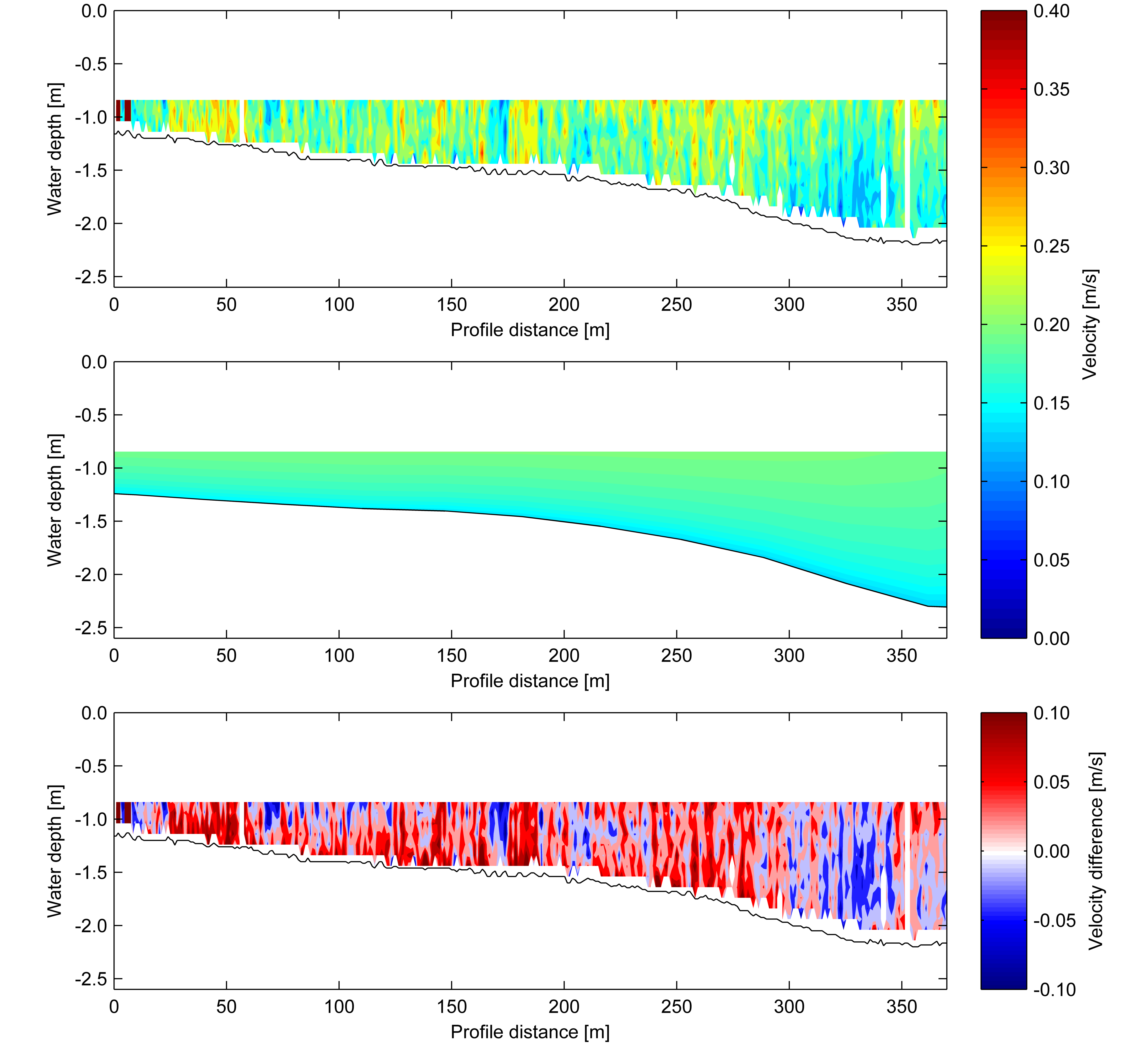
Fig.2: ADCP profile measured during a field survey (top), simulated 3D-current velocities (middle) and velocity differences (bottom), defined as observed minus simulated values, for October 11th 2013, 01:40 pm (UTC+8)
Additional datasets for further calibrating and validating the models, especially for the modeling of Yellow River Delta morphodynamics, will be gathered during a mid-2015 field campaign.