Wednesday 25 Jan 2017
Fontsize: [-] Text [+]

Agriculture


Agricultural Changes in the Yellow River Delta between 2004 and 2013

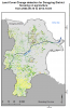
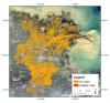
With the help of the Land Cover Maps from 2004 and 2013 generated and presented under Delta Dynamics already earlier post-classification change detection was performed with a focus on the development of the agricultural area in the Yellow River Delta. Therefore, the following figures show the conversion from agriculturally used fields into other land uses, as well as the amount of newly developed agricultural areas.

Distribution of agricultural areas in 2010

Agriculture plays an important role for the economy of Dongying district. The following figure illustrates the distribution of irrigated crops (red areas) and dry crops (orange areas) in the year 2010 within Dongying district. As can be seen from the figure, large parts of the Yellow River Delta were used for agriculture.

Copyright © 2018 German Aerospace Center (DLR)