Wednesday 25 Jan 2017
Fontsize: [-] Text [+]

Water Quality


New water quality parameters processed for 2002-2012

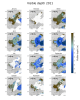
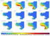
Processing of several new water quality parameters was conducted from MERIS data archive. Several L3 products, such as Chlorophyll, Visible Depth, Total Suspended Matter, and Turbidity, were processed with enhanced algorithms. Cloud detection could be improved. Exemplary, Figure 1 presents the Chlorophyll (CHL) concentration in the Bohai Sea for 2011 as aggregated monthly means. Figure 2 shows the Visible Depth (z90_max) for 2011 as monthly mean values. All water quality parameters were processed for the years 2002 to 2012. The spatial resolution of the information products is 300m.

Prognostic model scenario calculation

Prognostic model scenario calculations are processed in order to get a deeper understanding of possible distribution pathways of substances (e.g. water soluble substances or liquid substances insoluble in water) that could pass into the course of the river. The tracer modul of the utilized model system was adapted to the model region and is taking into account information such as water level, flow velocity, water and air temperature, and salinity of the river water.

CoastColour processing of MERIS data: changes and improvements on the processing chain

A new reprocessing of the water quality MERIS data from 2005-2012 has been put in place, with improved Water Quality algorithms provided by the CoastColour project and further adjustments for Delight. The processing contains several steps which are depicted in Figure 1. The first steps are a spatial and temporal subsetting from the MERIS FRS archive available at BC. The standard geolocation has been improved using the AMORGOS (Accurate MERIS Ortho-Rectified Geo-location Operational Software) tool, available from ESA and developed by ACRI-ST. Furthermore, the pre-processing includes a radiometric enhancement and an improved pixel classification.

Water quality parameters in the Bohai Sea

The Yellow River discharges into the Bohai Sea, which is located in the northern part of the east coast of China, with an area of 7.8 x 10⁴ km2. This sea is a semi-enclosed basin with four main parts: the Liaodong Bay up in the North, the Bohai Bay in the West, the Central Bohai Sea and the Laizhou Bay in the Southeast. The Bohai Strait separates the Bohai Sea from the Yellow Sea. The Bohai Sea is quite shallow, with an average depth of 18m.

Copyright © 2018 German Aerospace Center (DLR)