Wednesday 25 Jan 2017
Fontsize: [-] Text [+]

Hydrodynamics

Bathymetric Modelling of the Yellow River Delta Estuary

In order to integrate data acquired during the 2013 field campaign into a numerical model, a bathymetry for the estuary part of the Yellow River has to be generated. In a first step a closed landboundary boundary for the model was defined along the present coastline, which was extracted form so-called water mask products provided by the German Aerospace Center (DLR) (see Fig. 1). Furthermore, two open flow boundaries were implemented at the pontoon bridge, respectively 5 km seawards of the mouth of the estuary.

Numerical modeling of hydro- and morphodynamics in the Yellow River Delta and Bohai Sea

Numerical modeling is an established method for gaining insight into the estuarine circulation and mixing processes as well as sediment distributions, morphological dynamics and climate change impacts. Within the framework of DELIGHT such a numerical model of Yellow River Delta hydro- and morphodynamics is currently being developed at the Franzius-Institute for Hydraulic, Estuarine and Coastal Engineering. Furthermore, a numerical model of tidal dynamics for the adjacent Bohai Sea is implemented, in order to generate seaward boundary conditions for the delta model.

Acoustic Doppler current profiler measurements in the Yellow River Delta

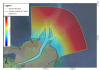
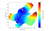
The Yellow River Delta (YRD) in China is a highly active morphodynamic environment subjected to both climatic driven naturally variations and anthropogenic stresses and other modes of transitions. The (DELIGHT) research project is aiming at developing an integrated management system for the Yellow River delta region. In October 2013, a field campaign was undertaken in the Yellow River Delta conducting vessel-based in-situ measurements of: water depth profiles and bottom sediment composition utilizing a parametric sub-bottom profiler, 3D-current velocities by Acoustic-Doppler-Current-Profiler (ADCP), conductivity, temperature, depth, oxygen saturation, pH and turbidity by CTD-probe, fluid densities by supersonic density probe and point velocities by electromagnetic current meter.

Field measurements of hydrodynamics and circulation in the Yellow River Estuary

During the DELIGHT field campaign in October 2013, vessel-based measurements were taken in the 20 km long estuarine section of the lower Yellow River and in the near shore Bohai Sea. A sediment echo-sounder (SES) was used to record water depths and bottom stratification. Flow velocities and discharge were measured using an acoustic Doppler current profiler (ADCP). Furthermore, vertical profiles of temperature, salinity, turbidity and fluid density were recorded with a CTD probe that was lowered through the water column. Additional water samples were taken for further analysis.


Alleviating Data Limitations in Coastal Flood Hazard Analysis: Reconstruction of Storm Surge Events by Meteorological Proxies

Surge-associated flooding has been a problem of key-importance for many areas around the world - see for example the catastrophic flood in the North Sea in 1953 (especially in the Netherlands). The Yellow River Delta in China, known for its floods and early flood-protection works, has witnessed an intense economical development over the past three decades. This development includes the extension of the Shengli oil field and urbanized areas in areas prone to storm surges. However, an encompassing hazard analysis for this Yellow river Delta does not exist.

Copyright © 2018 German Aerospace Center (DLR)