Wednesday 25 Jan 2017
Fontsize: [-] Text [+]

Urbanization

Application of the method for unsupervised change detection to the complete city of Dongying

In order to apply the methodology of unsupervised change detection on the complete city extent of Dongying, building geometries were delineated area-wide. The city comprises a total of around 30.000 buildings in 2013, whereas the number of changed buildings since 2006 was determined based on multi-temporal QuickBird and WorldView imagery by means of change detection.

Development of an unsupervised methodology for detection of changed buildings based on very-high resolution EO data

A new methodology for detection of changed buildings in a highly structured test site in the Eastern part of Dongying was developed and evaluated which will be transferred to the whole city area. The experimental site comprises about 550 individual buildings which were visually classified into changed (i.e. newly constructed) and unchanged buildings in order to provide a reference map for accuracy assessment.

Spatial urbanization 1992-2012 derived from multi-source EO data

In order to delineate the past urban extent occurred in the Yellow River Delta (YRD) region, an approach which jointly exploits temporal statistics extracted from multi-temporal ERS-1/2 PRI and ASAR IMP data and from multi-temporal Landsat-5/7 optical data was adopted. Specifically, it was taken into considerations to acquire imagery in 4 different periods of interests, namely 1992-1993, 1997-1998, 2002-2003, 2007-2008. The combination of the final maps reported the Figure below allows to characterize the extensive urbanization experienced by the YRD over 20 years from 1992 to 2012, with a greater increase starting from 2002-2003.

Building height estimation – intermediate results

Besides a proper delineation of the extent of built-up areas in the YRD, also a precise estimation of their height is of great importance for reliably characterizing the building volume and, hence, the distribution of the population in the region. In such framework, we implemented a novel unsupervised method developed for automatically deriving the height of built-up areas at the global scale based on the TanDEM-X Digital Elevation Model (DEM) and the Global Urban Footprint (GUF) layer produced at DLR-DFD.

Conclusions from the analysis of land-use dynamics and draft conception of CA model

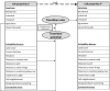
The objective of the preparatory work (literature review) and the field work (interviews, excursions) was the identification of characteristic settlement structures and determinants and trends of urban and regional development in order to adequately consider these for the development of the CA model (cellular automaton, CA).

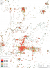
Conclusions: In the first project phase it was important to understand land-use dynamics and their determinants in the Yellow River Delta or Dongying region, respectively. As a result of this first phase, the initial hypothesis was confirmed that

Object-Oriented Classification and 3D-City Model - intermediate results

A precise estimation of building height is of great importance for reliably characterizing the building volume and, hence, the distribution of the population in the Yellow River Delta (YRD). To this aim we are implementing a fully unsupervised method developed for automatically deriving the height of built-up areas based on the 12 m spatial resolution digital elevation model (DEM) that will be available from the TanDEM-X mission (TDM).

Analysis of Dongying land-use dynamics – determinants and drivers

The objective of the October 2013 field work was to identify determinants and relevant mechanisms of urban growth in order to conceptualise the integration of urban and regional planning into the land-use model. Particular focus was laid on the role of spatial planning since we assume that it plays a central role for Dongying spatial development (e.g. Development Plan for High-efficiency Ecological Economic Zone of the Yellow River Delta, approved Nov. 2009 and Dongying Masterplan). In this context we were looking for information and evidence in the following fields:

Automatic Spatio-Temporal Mapping of Urban Areas in Dongying City - Preliminary Results

The entire Dongying City area, and particularly Dongying , are experiencing an intense urban development in the last decades. To properly monitor and analyse this key process, in the DELIGHT project we are developing advanced techniques based on satellite Earth Observation data.

Copyright © 2018 German Aerospace Center (DLR)