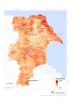
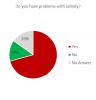
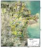
In February 2016 a master thesis with the title "Potentials of Earth observation data for the derivation of vulnerability indicators for the Yellow River Delta" was finished. The master student from HafenCity University Hamburg, Germany analysed all geospatial datasets for the Yellow River Delta available within the DELIGHT project, as well as all project results derived from remote sensing data, such as land cover, land use change, and water surface, etc. with respect to vulnerability of the Yellow River Delta towards impacts of industrial development on natural resources and on the population. Several vulnerability maps (see Figures 1 - 3) were generated to inform about the exposure of the river deltas natural resources and inhabitants towards different threads such as floods, water pollution, air pollution, etc.